Projection Transformation Package
The LAS 7.1 Projection Transformation Package is a system of subroutines designed to permit the transformation of coordinate pairs from one map projection to another. The primary "workhorse" of this package is the U.S. Geological Survey's General Cartographic Transformation Package (GCTP), although it has been buffered from the application routines to minimize changes to calling programs when the GCTP is changed or added to. A good reference on map projections is:
Snyder, John P., Map Projections--A Working Manual: U.S. Geological Survey Professional Paper 1395, United States Government Printing Office, Washington D.C., 1987.
Supported Projections
The following projections are supported by the Projection Transformation Package. All are available in the spherical form; many are available in the ellipsoidal form.
Alaska Conformal
Albers Conical Equal Area
Azimuthal Equidistant
Equidistant Conic
Equirectangular
General Vertical Near-Side Perspective
Geographic
Gnomonic
Hammer
Interrupted Goode Homolosine
Interrupted Mollweide
Integerized Sinusoidal
Lambert Azimuthal Equal Area
Lambert Conformal Conic
Mercator
Miller Cylindrical
Mollweide
Oblique Mercator (Hotine)
Oblated Equal Area
Orthographic
Polar Stereographic
Polyconic
Robinson
Sinusoidal
Space Oblique Mercator (SOM)
State Plane Coordinate System
Stereographic
Transverse Mercator
Universal Transverse Mercator (UTM)
Van Der Grinten
Wagner IV
Wagner VII
Projection Units
A list of supported units follows this paragraph. Meters are most commonly used for most projections; however, exceptions are radians, degrees, seconds, and packed degrees/ minutes/ seconds for geographic and a common use of feet for the State Plane Coordinate System.
          Radians
          Feet
          Meters
          Seconds of arc
          Degrees of arc
          Packed Degrees Minutes Seconds (DDDMMMSSS.SS)
Datum
LAS datums, along with the semi-major and semi-minor axes, are specified using a datum number. The datum number convention is that numbers less than 100 are simply spheroid definitions and are not tied to a particular datum. Datum numbers of 100 or greater are associated with a datum. Note that simple spheroid defintions (datum numbers < 100) should never be used if the user plans to overlay data from different sources. (See Warning in Note 6 below).
The semimajor axis and semiminor axis for a given datum may be selected via a datum code in projprm. For a list of supported datums and their values see the datum list or use the datum query tool.
Supported spheroids and their values: (in meters)
Spheroid number and name            Semimajor Axis   Semiminor Axis

0)  Clarke 1866                       6378206.4       6356583.8
1)  Clarke 1880                       6378249.145     6356514.86955
2)  Bessel                            6377397.155     6356078.96284
3)  International 1967                6378157.5       6356772.2
4)  International 1909                6378388.0       6356911.94613
5)  WGS 72                            6378135.0       6356750.519915
6)  Everest                           6377276.3452    6356075.4133
7)  WGS 66                            6378145.0       6356759.769356
8)  GRS 1980                          6378137.0       6356752.31414
9)  Airy                              6377563.396     6356256.91
10) Modified Everest                  6377304.063     6356103.039
11) Modified Airy                     6377340.189     6356034.448
12) WGS 1984                          6378137.0       6356752.3142
13) Southeast Asia                    6378155.0       6356773.3205
14) Australian National               6378160.0       6356774.719
15) Krassovsky                        6378245.0       6356863.0188
16) Hough                             6378270.0       6356794.343479
17) Mercury 1960                      6378166.0       6356784.283666
18) Modified Mercury 1968             6378150.0       6356768.337303
19) Mean Radius Sphere                6370997.0       6370997.0
20) Bessel 1841(Namibia)              6377483.865     6356165.382966
21) Everest (Sabah & Sarawak)         6377298.556     6356097.571445
22) Everest (India 1956)              6377301.243     6356100.228368
23) Everest (Malaysia 1969)           6377295.664     6356094.667915
24) Everest (Malay. & Singapore 1948) 6377304.063     6356103.038993
25) Everest (Pakistan)                6377309.613     6356108.570542
26) Hayford                           6378388.0       6356911.946128
27) Helmert 1906                      6378200.0       6356818.169
28) IndonesIAN 1974                   6378160.0       6356774.504086
29) South American 1969               6378160.0       6356774.719
30) WGS 60                            6378165.0       6356783.287
31) MODIS Sphere                      6371007.181     6371007.181
Zone codes
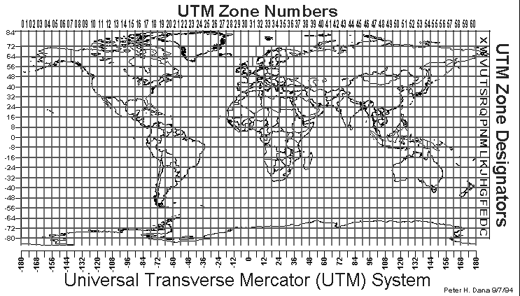
The Universal Transverse Mercator (UTM) and the State Plane Coordinate System use zone codes instead of specific projection parameters. The two tables which follow in Figure E-1 and E-3 list UTM and State Plane zone codes as used by the LAS 7.1 Projection Transformation Package. Figure E-2 shows UTM zones plotted on a world map (Figure E-2 source: Map Projections--A Working Manual: U.S. Geological Survey Professional Paper 1395). Equations for each State Plane zone are given in:
Clarie, Charles N, State Plane Coordinates by Automatic Data Processing, Publication 62-4, U.S. Department of Commerce, Environmental Science Services Administration, Coast and Geodetic Survey, United States Government Printing Office, Publication 624, 1973.
UTM Zone Codes, Locations, and Central Meridians
Figure E-2Zone C.M. Range
01 177W 180W-174W 02 171W 174W-168W 03 165W 168W-162W 04 159W 162W-156W 05 153W 156W-150W 06 147W 150W-144W 07 141W 144W-138W 08 135W 138W-132W 09 129W 132W-126W 10 123W 126W-120W 11 117W 120W-114W 12 111W 114W-108W 13 105W 108W-102W 14 099W 102W-096W 15 093W 096W-090W 16 087W 090W-084W 17 081W 084W-078W 18 075W 078W-072W 19 069W 072W-066W 20 063W 066W-060W 21 057W 060W-054W 22 051W 054W-048W 23 045W 048W-042W 24 039W 042W-036W 25 033W 036W-030W 26 027W 030W-024W 27 021W 024W-018W 28 015W 018W-012W 29 009W 012W-006W 30 003W 006W-000E 31 003E 000E-006E 32 009E 006E-012E 33 015E 012E-018E 34 021E 018E-024E 35 027E 024E-030E 36 033E 030E-036E 37 039E 036E-042E 38 045E 042E-048E 39 051E 048E-054E 40 057E 054E-060E 41 063E 060E-066E 42 069E 066E-072E 43 075E 072E-078E 44 081E 078E-084E 45 087E 084E-090E 46 093E 090E-096E 47 099E 096E-102E 48 105E 102E-108E 49 111E 108E-114E 50 117E 114E-120E 51 123E 120E-126E 52 129E 126E-132E 53 135E 132E-138E 54 141E 138E-144E 55 147E 144E-150E 56 153E 150E-156E 57 159E 156E-162E 58 165E 162E-168E 59 171E 168E-174E 60 177E 174E-180W
Jurisdictions, State Plane Coordinate Systems, and Zone
Representations
Alabama
East 0101 0101
West 0102 0102
Alaska
01 through 10 5001 5001
thru 5010 5010
Arizona
East 0201 0201
Central 0202 0202
West 0203 0203
Arkansas
North 0301 0301
South 0302 0302
California
01 through 07 0401 0401
thru 0407 0406
Colorado
North 0501 0501
Central 0502 0502
South 0503 0503
Connecticut 0600 0600
Delaware 0700 0700
District of Columbia 1900 1900
Florida
East 0901 0901
West 0902 0902
North 0903 0903
Georgia
East 1001 1001
West 1002 1002
Hawaii
01 through 05 5101 5101
thru 5105 5105
Idaho
East 1101 1101
Central 1102 1102
West 1103 1103
Illinois
East 1201 1201
West 1202 1202
Indiana
East 1301 1301
West 1302 1302
Iowa
North 1401 1401
South 1402 1402
Kansas
North 1501 1501
South 1502 1502
Kentucky
North 1601 1601
South 1602 1602
Louisiana
North 1701 1701
South 1702 1702
Offshore 1703 1703
Maine
East 1801 1801
West 1802 1802
Maryland 1900 1900
Massachusetts
Mainland 2001 2001
Island 2002 2002
Michigan
East(Trans Merc) 2101 ----
Central(Trans Merc) 2102 ----
West(Trans Merc) 2103 ----
North(Lambert) 2111 2111
Central(Lambert) 2112 2112
South(Lambert) 2113 2113
Minnesota
North 2201 2201
Central 2202 2202
South 2203 2203
Mississippi
East 2301 2301
West 2302 2302
Missouri
East 2401 2401
Central 2402 2402
West 2403 2403
Montana ---- 2500
North 2501 ----
Central 2502 ----
South 2503 ----
Nebraska ---- 2600
North 2601 ----
South 2602 ----
Nevada
East 2701 2701
Central 2702 2702
West 2703 2703
New Hampshire 2800 2800
New Jersey 2900 2900
New Mexico
East 3001 3001
Central 3002 3002
West 3003 3003
New York
East 3101 3101
Central 3102 3102
West 3103 3103
Long Island 3104 3104
North Carolina 3200 3200
North Dakota
North 3301 3301
South 3302 3302
Ohio
North 3401 3401
South 3402 3402
Oklahoma
North 3501 3501
South 3502 3502
Oregon
North 3601 3601
South 3602 3602
Pennsylvania
North 3701 3701
South 3702 3702
Rhode Island 3800 3800
South Carolina ---- 3900
North 3901 ----
South 3902 ----
South Dakota
North 4001 4001
South 4002 4002
Tennessee 4100 4100
Texas
North 4201 4201
North Central 4202 4202
Central 4203 4203
South Central 4204 4204
South 4205 4205
Utah
North 4301 4301
Central 4302 4302
South 4303 4303
Vermont 4400 4400
Virginia
North 4501 4501
South 4502 4502
Washington
North 4601 4601
South 4602 4602
West Virginia
North 4701 4701
South 4702 4702
Wisconsin
North 4801 4801
Central 4802 4802
South 4803 4803
Wyoming
East (01) 4901 4901
East Central (02) 4902 4902
West Central (03) 4903 4903
West (04) 4904 4904
Puerto Rico 5201 5200
Virgin Islands ---- 5200
St. John,
St. Thomas 5201 ----
St. Croix 5202 ----
American Samoa 5300 ----
Guam 5400 ----
Projection Parameter
The LAS Projection Transformation Package uses a double precision array of
fifteen elements to send projection specific parameters to the Projection
Transformation Package. Normally, projection parameters are entered through
the projprm module, which doesn't
require the user to know the array location and format of each projection
parameter. However, the locations of each projection parameter need to be
known when looking at a projection definition file (output from
projprm), when editing a geometric
mapping grid file (module editgrid),
when editing a tie point file (module
edittie), or when editing an image DDR (module
editddr).
in packed DMS format
Parameter 9 103.2669323
Parameter 10 0.5201613
Parameter 5 129.3 degrees - (360/233 * path number)
in packed DMS format
Parameter 9 98.884119
Parameter 10 0.5201613
Figure E-3
NAD27 NAD83
Jurisdiction Zone Zone
Zone name or number Code Code
Obtained from Software Documentation for GCTP General Cartographic
Transformation Package: National Mapping Program Technical Instructions,
U.S. Geological Survey, National Mapping Division, October 1990, Appendix A.Projection Transformation Package Projection
Parameters
-----------------------------------------------------------------------------
                        |                   Array Element                   |
 Code & Projection Id   |----------------------------------------------------
                        |   1  |   2  |  3   |  4   |   5   |    6    |7 | 8|
-----------------------------------------------------------------------------
 0 Geographic (Note 6)  |      |      |      |      |       |         |  |  |
 1 U T M                |Lon/Z |Lat/Z |      |      |       |         |  |  |
 2 State Plane          |      |      |      |      |       |         |  |  |
 3 Albers Equal Area    |SMajor|SMinor|STDPR1|STDPR2|CentMer|OriginLat|FE|FN|
 4 Lambert Conformal C  |SMajor|SMinor|STDPR1|STDPR2|CentMer|OriginLat|FE|FN|
 5 Mercator             |SMajor|SMinor|      |      |CentMer|TrueScale|FE|FN|
 6 Polar Stereographic  |SMajor|SMinor|      |      |LongPol|TrueScale|FE|FN|
 7 Polyconic            |SMajor|SMinor|      |      |CentMer|OriginLat|FE|FN|
 8 Equid. Conic A       |SMajor|SMinor|STDPAR|      |CentMer|OriginLat|FE|FN|
   Equid. Conic B       |SMajor|SMinor|STDPR1|STDPR2|CentMer|OriginLat|FE|FN|
 9 Transverse Mercator  |SMajor|SMinor|Factor|      |CentMer|OriginLat|FE|FN|
10 Stereographic        |Sphere|      |      |      |CentLon|CenterLat|FE|FN|
11 Lambert Azimuthal    |Sphere|      |      |      |CentLon|CenterLat|FE|FN|
12 Azimuthal            |Sphere|      |      |      |CentLon|CenterLat|FE|FN|
13 Gnomonic             |Sphere|      |      |      |CentLon|CenterLat|FE|FN|
14 Orthographic         |Sphere|      |      |      |CentLon|CenterLat|FE|FN|
15 Gen. Vert. Near Per  |Sphere|      |Height|      |CentLon|CenterLat|FE|FN|
16 Sinusoidal           |Sphere|      |      |      |CentMer|         |FE|FN|
17 Equirectangular      |Sphere|      |      |      |CentMer|TrueScale|FE|FN|
18 Miller Cylindrical   |Sphere|      |      |      |CentMer|         |FE|FN|
19 Van der Grinten      |Sphere|      |      |      |CentMer|OriginLat|FE|FN|
20 Hotin Oblique Merc A |SMajor|SMinor|Factor|      |       |OriginLat|FE|FN|
   Hotin Oblique Merc B |SMajor|SMinor|Factor|AziAng|AzmthPt|OriginLat|FE|FN|
21 Robinson             |Sphere|      |      |      |CentMer|         |FE|FN|
22 Space Oblique Merc A |SMajor|SMinor|      |IncAng|AscLong|         |FE|FN|
   Space Oblique Merc B |SMajor|SMinor|Satnum|Path  |       |         |FE|FN|
23 Alaska Conformal     |SMajor|SMinor|      |      |       |         |FE|FN|
24 Interrupted Goode    |Sphere|      |      |      |       |         |  |  |
25 Mollweide            |Sphere|      |      |      |CentMer|         |FE|FN|
26 Interrupt Mollweide  |Sphere|      |      |      |       |         |  |  |
27 Hammer               |Sphere|      |      |      |CentMer|         |FE|FN|
28 Wagner IV            |Sphere|      |      |      |CentMer|         |FE|FN|
29 Wagner VII           |Sphere|      |      |      |CentMer|         |FE|FN|
30 Oblated Equal Area   |Sphere|      |Shapem|Shapen|CentLon|CenterLat|FE|FN|
31 Integerized Sinusoid |Sphere|      |      |      |CentMer|         |FE|FN|
-----------------------------------------------------------------------------

Projection Transformation Package Projection Parameters elements 9-15

     ----------------------------------------------------
                             |      Array Element       |
      Code & Projection Id   |---------------------------
                             |  9  | 10 |  11 | 12 | 13 |
     ----------------------------------------------------
      0 Geographic (Note 6)  |     |    |     |    |    |
      1 U T M                |     |    |     |    |    |
      2 State Plane          |     |    |     |    |    |
      3 Albers Equal Area    |     |    |     |    |    |
      4 Lambert Conformal C  |     |    |     |    |    |
      5 Mercator             |     |    |     |    |    |
      6 Polar Stereographic  |     |    |     |    |    |
      7 Polyconic            |     |    |     |    |    |
      8 Equid. Conic A       |zero |    |     |    |    |
        Equid. Conic B       |one  |    |     |    |    |
      9 Transverse Mercator  |     |    |     |    |    |
     10 Stereographic        |     |    |     |    |    |
     11 Lambert Azimuthal    |     |    |     |    |    |
     12 Azimuthal            |     |    |     |    |    |
     13 Gnomonic             |     |    |     |    |    |
     14 Orthographic         |     |    |     |    |    |
     15 Gen. Vert. Near Per  |     |    |     |    |    |
     16 Sinusoidal           |     |    |     |    |    |
     17 Equirectangular      |     |    |     |    |    |
     18 Miller Cylindrical   |     |    |     |    |    |
     19 Van der Grinten      |     |    |     |    |    |
     20 Hotin Oblique Merc A |Long1|Lat1|Long2|Lat2|zero|
        Hotin Oblique Merc B |     |    |     |    |one |
     21 Robinson             |     |    |     |    |    |
     22 Space Oblique Merc A |PSRev|LRat|PFlag|    |zero|
        Space Oblique Merc B |     |    |     |    |one |
     23 Alaska Conformal     |     |    |     |    |    |
     24 Interrupted Goode    |     |    |     |    |    |
     25 Mollweide            |     |    |     |    |    |
     26 Interrupt Mollweide  |     |    |     |    |    |
     27 Hammer               |     |    |     |    |    |
     28 Wagner IV            |     |    |     |    |    |
     29 Wagner VII           |     |    |     |    |    |
     30 Oblated Equal Area   |Angle|    |     |    |    |
     31 Integerized Sinusoid |NZone|    |RFlag|    |    |
     ----------------------------------------------------

  where
      Lon/Z     Longitude of any point in the UTM zone or zero.  If
                zero, a zone code must be specified. (Note 3)
      Lat/Z     Latitude of any point in the UTM zone or zero.  If zero,
                a zone code must be specified. (Note 3)
      SMajor    Semi-major axis of ellipsoid.  If zero, Clarke 1866 in
                meters is assumed. (Note 4)
      SMinor    Eccentricity squared of the ellipsoid if less than one,
                or if greater than one, the semi-minor axis of ellipsoid.
                (Note 4)
      Sphere    Radius of reference sphere.  (Notes 4 & 5)
      STDPAR    Latitude of the standard parallel (Note 3)
      STDPR1    Latitude of the first standard parallel (Note 3)
      STDPR2    Latitude of the second standard parallel (Note 3)
      CentMer   Longitude of the central meridian (Note 3)
      OriginLat Latitude of the projection origin (Note 3)
      FE        False easting in the same units as the semi-major axis
      FN        False northing in the same units as the semi-major axis
      TrueScale Latitude of true scale (Note 3)
      LongPol   Longitude down below pole of map (Note 3)
      Factor    Scale factor at central meridian (Transverse Mercator) or
                center of projection (Hotine Oblique Mercator)
      CentLon   Longitude of center of projection (Note 3)
      CenterLat Latitude of center of projection (Note 3)
      Height    Height of perspective point (Note 4)
      Long1     Longitude of first point on center line (Hotine Oblique
                Mercator, format A) (Note 3)
      Long2     Longitude of second point on center line (Hotine Oblique
                Mercator, format A) (Note 3)
      Lat1      Latitude of first point on center line (Hotine Oblique
                Mercator, format A) (Note 3)
      Lat2      Latitude of second point on center line (Hotine Oblique
                Mercator, format A) (Note 3)
      AziAng    Azimuth angle east of north of center line (Hotine Oblique
                Mercator, format B) (Note 3)
      AzmthPt   Longitude of point on central meridian where azimuth occurs
                (Hotine Oblique Mercator, format B) (Note 3)
      IncAng    Inclination of orbit at ascending node, counter-clockwise
                from equator (SOM, format A) (Note 3)
      AscLong   Longitude of ascending orbit at equator (SOM, format A) (Note 3)
      PSRev     Period of satellite revolution in minutes (SOM, format A)
      LRat      Landsat ratio to compensate for confusion at northern end
                of orbit (SOM, format A -- use 0.5201613)
      PFlag     End of path flag for Landsat:  0 = start of path,
                1 = end of path (SOM, format A)
      Satnum    Landsat Satellite Number (SOM, format B)
      Path      Landsat Path Number (Use WRS-1 for Landsat 1, 2 and 3 and
                WRS-2 for Landsat 4, 5, 6, and 7.)  (SOM, format B)
      Shapem    Oblated Equal Area oval shape parameter m
      Shapen    Oblated Equal Area oval shape parameter n
      Angle     Oblated Equal Area oval rotation angle
      NZone     Number of equally spaced latitudinal zones (or rows).  Must be
                larger than 2, not more than 1296000 (1 zone per second), and
                an even number.
      RFlag     Right justify columns flag is used to indicate what to do with
                zones with an odd number of columns.  A value of zero or one
                indicates the extra column is on the right (zero) or left (one)
                of the projection y-axis.  A value of 2 indicates the number of
                columns is forced to be even in each zone.


                                   NOTES

   (1) Array elements 14 and 15 are set to zero
   (2) All array elements with blank fields are set to zero.
   (3) All angles (latitudes, longitudes, azimuths, etc.) are entered in packed
           degrees/ minutes/ seconds (DDDMMMSSS.SS) format.
   (4) Units are meters.  The semi-major and semi-minor axes are actually
       obtained from the datum code field of an image DDR or projection
       parameter file.  The semi-major and semi-minor axes must agree with the
       specified datum code.
   (5) The following projections are only available when the surface of the
       earth is defined as a sphere:
          * Stereographic                  * Lambert Azimuthal
          * Azimuthal                      * Gnomonic
          * Orthographic                   * Gen. Vert. Near Per
          * Sinusoidal                     * Equirectangular
          * Miller Cylindrical             * Van der Grinten
          * Robinson                       * Interrupted Goode
          * Mollweide                      * Interrupt Mollweide
          * Hammer                         * Wagner IV
          * Wagner VII                     * Oblated Equal Area
          * Integerized Sinusoid
       Since LAS uses the datum code field to determine the semi-major and/or
       sphere radius, the datum related axes are overridden with the Mean
       Radius of the earth sphere value of 6370997 meters for these projections.
       This allows the user to keep the reference datum and still use these
       projections.  The only datum/spheroid code that will not be overridden
       is the MODIS sphere.
  (6)The geographic projection reports geodetic latitudes.
       Geodetic latitudes change based on the spheroid used.
          WARNING: When datum numbers less than 100 are used, the latitudes are
                   not corrected when an ellipsoid change is involved during a
                   projection transformation.  This affects projection
                   transformations even when neither projection is geographic
                   since all projections go through the geographic projection
                   during the transformation.  This means that reported latitude
                   values will not match up to real locations on the ground.
                   If datum numbers of 100 or larger are used, this is not
                   a problem since the ellipsoid change is handled properly.
                   This is the main reason users should use datum numbers of
                   100 or greater any time they can.
The following notes apply to the Space Oblique Mercator projection, format A:
Parameter 4 099005031.2
Parameter 5 128.87 degrees - (360/251 * path number)
Parameter 4 098012000.0