Synoptic Climatology of the SRB
SRBEX research in synoptic climatology had five goals in 1994-5:
- To identify what types of storm systems induce high discharge on average
- To determine the nature of storm systems that produce extreme discharge
events
- To establish how watersheds of differing basin scales respond to synoptic
forcing
- To find out which circulation patterns and their hydrologic responses
are representative
- To develop techniques for monitoring large-scale hydroclimatic variation
High Average Discharge
One goal of the research was to see which frequently recurring weather events
are consistently associated with high, but not necessarily extreme, discharge.
To this end, Yarnal and Frakes (1995a) examined 12 years of daily weather
maps from 1978 to 1989 (Yarnal, 1993) using the sequencing methodology
of Comrie (1992). These synoptic sequences are somewhat similar to output
from mesoscale meteorological models and relate to discharge from individual
river basins. Consequently, we analyzed the most frequent two-day and three-day
weather-map sequences associated with high average-daily discharge from
thirty basins distributed evenly over the SRB. The discharges from these
sub-basins operate at three distinct orders of magnitude that correlate
with basin size, and are referred to as small, medium and large basins for
convenience (Table 2). We analyzed 11 types of storm sequences and found
that these storm systems do produce high discharge from the study basins
almost every time they occur.
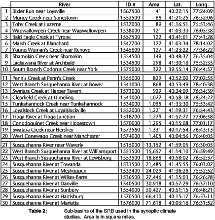
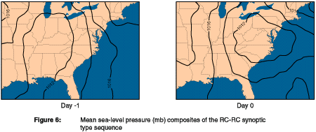
To illustrate, Figure 6 shows the average pressure pattern for the cyclonic
conditions with rain synoptic type sequence (RC-RC). The RC-RC is the most
frequent of the sequences associated with high average discharge, occurring
on average nearly eight times per year. It is most common from late fall
through mid-spring, with peak frequencies occurring in February through
April; it is infrequent in summer. On Day-1 of this two-day sequence, a
low-pressure system moves into the Midwest, while the pressure gradient
directs southeasterly flow off the mid-Atlantic coast into the SRB. By Day-0,
the low moves east and intensifies, winds over the SRB are now from the
east, and precipitation is falling steadily on the basin. The storm system
is tapping into the ready supply of Atlantic moisture.
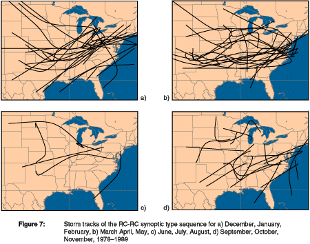
Similar to Yarnal and Draves (1993), we plotted each of the storm tracks
associated with the high average-discharge sequences. For instance, the
RC-RC storm tracks exhibit a clear northeast ward direction and a distinctive
seasonal cycle (Figure 7). Because the circumpolar vortex reaches its southernmost
extent in winter, the storms that form in this season tend to come from
the southern Great Plains and Gulf of Mexico. Springtime lows originate
slightly to the north. The few RC-RC sequences that arise in summer
form much farther north and have erratic, slow-moving paths. Early autumn
storm tracks look like those of summer, but by late fall originate much
farther south, are more intense, and move more quickly.
Similar analysis of the 10 other most frequent weather-map sequences
associated with the SRB's high average discharge demonstrates that these
synoptic-scale weather systems typically draw their moisture from the mid-Atlantic.
This moisture source is quite different to those systems pro ducing extreme
discharge in the SRB.
Extreme Discharge
To determine the nature of storm systems that produce extreme discharge
events, Frakes and Yarnal (1995c) performed a similar analysis to the one
described above. The biggest difference was that weather-map sequences had
to occur when discharge was greater than one standard deviation above the
lognormal mean. During the 12-year study period, there were 589 days when
at least one of the 30 basins experienced extreme discharge and a total
of 5383 extreme-discharge basin days. There were 10 two-day or three-day
sequences most often associated with these high flows.
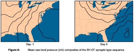
For example, the pressure composite of the western side of a high-pressure
cell synoptic type sequence (BH-CF) (Figure 8) shows a large Bermuda
High over the Atlantic Ocean on Day -1. The strong pressure gradient between
the high- and low-pressure centers generates southwesterly winds that advect
warm, moist Gulf of Mexico moisture northeastward to the SRB. Typically,
a cold-front extends southward from the low. By Day -0, this low has tracked
east with the cold front passing over the SRB. As the front approaches,
the weakened Bermuda High migrates southeastward, but continues to pump
Gulf air into the warm sector ahead of the front. At least during warm months,
conditions are stormy, with localized convective precipitation.
The BH-CF tends to be a warm-season phenomenon, with the most
occurrences and most frequent extreme discharge during summer months. It
does occur infrequently and produce extreme discharge in late winter-early
spring; however, in these cases, the high runoff totals are the result of
warm-air advection and snow melt on Day-1 not intense precipitation. Of
the 234 times the BH-CF sequence occurred during the study period, it induced
extreme discharge 120 times in at least one sub-basin of the SRB.
In summary, this analysis demonstrates that the SRB's extreme discharge
events usually involve a combination of powerful high-pressure systems,
intense pressure gradients, and very warm, moist, southerly air from the
Gulf of Mexico. In contrast, high average discharge relies on prolonged
low pressure over the basin and easterly moisture flow off the mid-Atlantic
coast. Extreme discharge events in the cold season result from the same
weather patterns that generate warm-season extreme flows, except that snow
melt, rather than localized convection, produces exceptionally high stream
levels.
Scales of Response
Through modeling and observation, SRBEX seeks to determine how watersheds
of differing scales respond to forcing by weather systems. For the observational
component of this objective, Frakes (1995) and Frakes and Yarnal (1995a,b)
stratified the discharge from the 30 watersheds by the synoptic type sequences
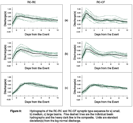
presented above. Composite hydrographs associated with the RC-RC sequence
discussed above depict the responses of small, medium, and large basins
(Figure 8). Looking only at the heavy, dark line that indicates the average
flow from all 10 basins in a size category, the small basins respond strongly
on Day-0. Note that discharge is already about 0.25 standard deviations
above mean flow on Day-1, suggesting that the first day in the sequence
has already saturated the soil by Day-0. Also, the days following this weather-map sequence show gradually decreasing discharge, suggesting raised base
flows and the possibility of prolonged wet weather. Individual basins,
marked by the fine, dashed lines, have similar response curves, but differ
in magnitude. As water funnels into the medium basins from upstream, the
hydrographic traces show a stronger response to the RC-RC sequence with
a large, rounded peak. This response lags the small basins by a day. The
responses of the down stream large basins are as strong as the medium-sized
basins, but not stronger, and are delayed two to three days. In contrast
to the small and medium-sized basins, large basins have very little deviation
around the composite response curve.
It is instructive to compare the RC-RC hydrographs with those of other synoptic
type sequences. For example, the cyclonic conditions with rain-cold
front sequence (RC-CF), which denotes the classic southwest-to-northeast
succession of a warm front followed by a cold front, produces a distinctly
different set of basin responses (Figure 9). The small-basin hydrographic
traces exhibit a sharp, strong response on Day-0, but stream levels drop
off quickly over the next two days. Medium-sized basins also have a sharp,
but slightly weaker response a half-day later. The large basins take two
days to achieve peak response, and flow levels do not drop off rapidly after
the event.
Thus, this part of the research confirms a well-known principle in basin
hydrology: small basins respond the quickest to runoff events, while the
response times of larger basins lag according to their distance downstream
from the headwaters. However, what is unique to this research is the conclusion
that this lag time varies with the storm trajectory and type.
Representative Hydroclimatic Events
Nested-modeling efforts, such as SRBEX, assume that there is a strong causal
relationship between the atmospheric circulation and the hydrologic response
of the basin. Many of the simulations linking the atmosphere and basin hydrology
rely on observed events believed to be typical. Yet no methodology has been
developed to determine either the representativeness of the circulation
patterns producing a significant hydrologic response, or the representativeness
of the hydrologic response to a given storm system. Thus, to determine
which circulation patterns and their hydrologic responses are representative,
Yarnal and Frakes (1995b) scrutinized the results presented above.
As suggested by the differences between the RC-RC and RC-CF sequences,
each weather-map sequence produces a unique hydrographic response. In any
one size category and assuming somewhat similar geology, vegetation, and
soils, only those basins that have suffered extreme land-surface modification
or flow control show radically differing hydrographs. This is an extremely
important finding because it suggests that, in a general region, almost
any basin with good measurements is "representative" of its scale.
This work also demonstrates that hydrologic and meteorological models must
be able to simulate the flow from many different precipitation patterns
over time and space. If a hydrologic model reproduces the hydrographic trace
of a generic, average precipitation or snow melt event, it does not necessarily
mean that the model is a success; it must be able to generate lifelike responses
to many kinds of weather events. Similarly, mesoscale meteorological models
must be able to simulate the precipitation from a wide range of meteorological
scenarios. Thus, the results suggest that synoptic climatology is a useful
tool for defining model scenarios and for model verification in global-change
experiments.
Monitoring Large-Scale Hydroclimatic Variation and Future Work
The fifth goal of the synoptic climatological research was to develop ways
to monitor large-scale climatic variation over the SRB. Yarnal and Frick
(1995) are creating a catalog of daily eigenvector-based synoptic map patterns,
plus indices based on these patterns (Yarnal, 1993) for the period 1946-1994.
Quarterly updates of the catalog will be available from the Northeast Regional Climate Center in hard copy and over the Internet starting in the
last quarter of 1995. These data will be integral to developing long-range
forecasts of basin climate and hydrology.
From this starting point, the next phase of the synoptic climatological
work will focus on long-term, large-scale climate-runoff relationships in
the SRB. To date, the research has concentrated on relationships between
daily synoptic-scale circulation and discharge at various basin scales.
The new emphasis will be on translation among both spatial and temporal
scales. Specifically, the research will involve:
- Linking planetary-scale and synoptic-scale circulations, and developing
relationships between these large-scale atmospheric phenomena and basin
responses.
- Connecting atmospheric-circulation and discharge patterns with processes
at daily, monthly, seasonal, annual and decadal time scales, including the
linkages be tween daily and longer time scales.
Understanding these spatial and temporal relationships is intrinsically
important to basic science. Furthermore, developing knowledge of these
associations provides a baseline for guiding and evaluating the nested-model
experiments of SRBEX. This work is especially important to linking the GCM
and mesoscale meteorological model and projecting future basin responses
from large-scale model and satellite-observed data.
The Penn State/NCAR Mesoscale Model (MM) is a versatile three-dimensional,
limited-area meteorological numerical model. The 5th generation
of the MM (MM5) has been chosen for SRBEX applications because it is a state-of-the-science
model. MM5 is nonhydrostatic, it allows for multiple movable nested domains,
and it has a sophisticated atmospheric hydrologic cycle module, an improved
atmospheric radiation scheme, and efficient numerics to make longer-range
simulations more efficient. It can be initialized with observed or synthetic
atmospheric data and can be applied to any region on earth. MM5 has been
tested on a number of meteorological cases over a wide range of scales where
the emphasis has been on the hydrologic cycle and the surface forcing. All
these features make MM5 an excellent choice for studying regional climate
changes with emphasis on the water cycle.
Version 1 of MM5 was officially released for public use in February 1994.
The entire MM5 system (including pre- and post-processing programs) was
transferred to the ESSC CRAY YMP, and the necessary changes and tests to
run those programs on that platform were made.
During 1994 a modified version of the Biosphere-Atmosphere Transfer Scheme
(BATS) (Lakhtakia and Warner, 1994) was introduced into MM5, so that the
latter can be used as part of the SRBEX suite of models. Much emphasis has
been put on the improvement of some of the variables/parameters within
BATS that require initialization/specification. BATS requires the initialization of the soil water (SW) content and the specification of some surface
characteristics. At present, MM5 is the model being used to develop and
test the linkages with the SHM and Terrestrial Hydrology Model (THM) described
below (and shown in Figure 3). In the near future, MM5 will replace the
RegCM2 (based on MM4) as the model coupled to the GCM. The MM5 multiple-nesting
capability will provide dynamically consistent "downscaling" capabilities required to link the large scale of the GCM to the local scale of the
THM.
 Table of Contents
 Previous Section
 Next
Section
 Download Report
Graphics and HTML text markup by Phil Kolb
Comments to: R. White, raw@essc.psu.edu


 Table of Contents
 Previous Section
 Next
Section
 Download Report