
Figure 1
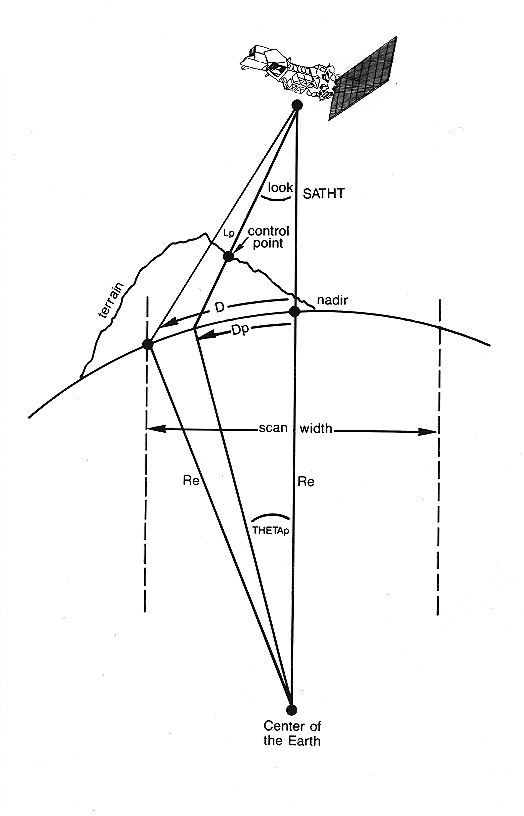
Figure 2
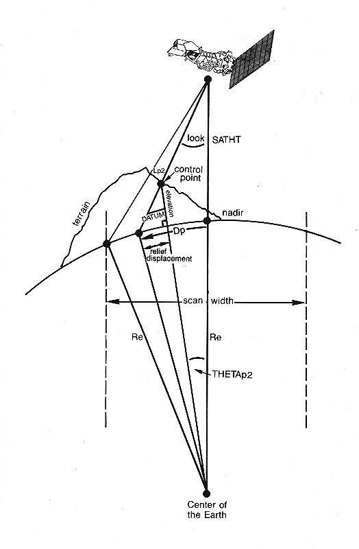
Figure 3
Corrects ground control points for relief displacement
Corrects ground control points for relief displacement errors due to terrain to a user-entered datum.
- INTL
- Input tie point location file. This file contains control points which are to be adjusted for the effects of relief. The unit of measure of the coordinates is specified in the file header record.
- OUTTL
- Output tie point location file. This tie point location file contains adjusted coordinates. The unit of measure of the coordinates is described in the file header record.
- PIXSIZ
- Pixel size. The pixel size in meters of the image whose control points are being corrected for relief displacement.
- QUADNUM(0.0)
- TM quad number. The number of the TM quad used. This parameter should be zero if a full TM scene is used or if the imagery used is other than TM data. If a combination of TM quads are used, set QUADNUM to zero if the top or bottom half is used or set QUADNUM to one of the quads used if either the right or left half is used.
- SATHT(705000.0)
- Satellite height. The height of the satellite above the earth in meters. Use:
  = 822000.0 for SPOT
  = 705000.0 for Landsat 4, 5, 7
  = 920000.0 for Landsat 1, 2, 3
- INCANG(0.0)
- Incidence angle. The incidence angle of the SPOT HRV sensor in degrees. This value is found on SPOT summary sheets where L makes the angle positive and R makes the angle negative. The look angle of the first CCD detector is INCANG - 2.065. If using Landsat data, set this parameter to zero.
- FOVIEW(14.94)
- Field-of-view. The angle in degrees between the first and last detector (or sample) of a scanline. Use:
   =  4.13 for SPOT
   = 14.94 for Landsat
- PITCH(0.0)
- Pitch. Scanline pitch from nadir in degrees.
   =  0.53 for SPOT Panchromatic
   = -0.53 for SPOT XS
   =  0.0  for Landsat
- DATUM(0.0)
- Datum. The reference elevation to which the relief displacement is adjusted to. The units of DATUM are specified in the DATUNIT parameter.
- DATUNIT("METERS")
- Datum unit. The unit of measure for the DATUM parameter. Valid units are feet or meters.
- PRINT("TERM")
- Output destination. The destination of the output.
  = --:        No Report
  = TERM:      Terminal.  Output is sent to the user's
               terminal.
  = LP:        Line printer.  Output is sent to the
               printer defined by $PRINTER.
  = Filename:  User-supplied filename.  Output is sent
               to the user-supplied file with the
               extension ".prt".
The example above gives the parameters for adjusting control points (search image tie points) obtained from a full scene Landsat 4 or 5 TM image. The search points in CONTROL are corrected for relief and written to ADJUST. The results are reported to the user.
LAS processing is initialized and parameters are received via TAE. The sensor specific parameters for relief displacement correction are reported to the user. Next, the tie point location file containing the control points to be adjusted for the effects of relief is opened and it's header data read. The output tie point location file is then opened, and the header record from the input file is copied to the output file. As each point record is read, the search image coordinates are adjusted for relief displacement effects in the following manner:
  If TM quad (QUADNUM) 2 or 4 is used, adjust the sample
  location:

     sample = sample + 2747.0

  Calculate the look angle at the start of scan and convert
  it to radians:

     PHI = (INCANG - (FOVIEW / 2)) * Degrees-to-Radians

  Using Figure 1, find the line-of-sight distance from the
  beginning of the scanline to the satellite:

     L = (Re + SATHT) * cos(PHI) - Re *
          sqrt(1 - (((Re + SATHT) / Re) * sin(PHI))**2)

  Find the central earth angle between the beginning of the
  scanline and the satellite nadir:

     THETA = asin((L / Re) * sin(PHI))

  Find the distance on the earth's surface from nadir to
  the scanline:

     D = Re * THETA

  Using Figure 2, find the distance on the earth's surface
  from the control point to nadir:

     Dp = D + (sample - 1) * PIXSIZ

  Calculate the central earth angle between the control
  point and the satellite nadir without taking the elevation
  of the control point into account:

     THETAp = Dp / Re

  Calculate the line-of-sight distance of the control point
  from the satellite, with the elevation of the control
  point not taken into account:

     Lp = sqrt(Re**2 + (Re + SATHT)**2 -
          2 * Re * (Re + SATHT) * cos(THETAp))

  Calculate the look angle of detector where the point was
  imaged:

     look = asin((Re / Lp) * sin(THETAp))

  Using Figure 3, calculate the line-of-sight distance of
  the control point from the satellite, taking the elevation
  of the control point into account:

     Lp2 = (Re + SATHT) * cos(look) - (Re + elevation) *
            sqrt(1 - ((Re + SATHT) / (Re + elevation) *
            sin(look))**2)

  Calculate the central earth angle between the control
  point and the satellite nadir, taking elevation of the
  control point into account:

     THETAp2 = asin(Lp2 / (Re + elevation) * sin(look)

  Calculate the relief displacement in meters (straight
  line displacement and not on an arc) :

     relief = (elevation - DATUM) * tan(look + THETAp2)

  Calculate the new sample location:

     new_sample = sample - (relief / PIXSIZ)

  Adjust the scanline.  If the sensor PITCH is zero, as it is
  for Landsat, there will be no change in the line location.

     relief = tan(PITCH * Degrees-to-Radians) *
              (elevation - DATUM)
     new_line = line - (relief / PIXSIZ)

  If TM quad (QUADNUM) 2 or 4 is used, readjust the sample
  location:

     new_sample = new_sample - 2747.0
Each record is written to the output file and to a report for the user. Processing completes.
The message displayed immediately preceding this message is the specific error encountered. Processing is terminated.
Figure 1
Figure 2
Figure 3